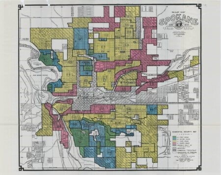
1929 Redlining Map of Spokane
This file appears in: The Origins of Segregated Neighborhoods in Spokane
A 1929 redlining map on YWCA Spokane’s website. Redlining maps such as this one were used by developers, homebuyers, and others to assess the demographics and the values of houses in different areas of Spokane. Many of the homes near Spokane’s first neighborhood racial covenant in East Audubon Park received A and B ratings.
This file appears in: The Origins of Segregated Neighborhoods in Spokane
The Origins of Segregated Neighborhoods in Spokane
Discrimination and segregation were common in Spokane much of the early-mid 20th Century. Segregated neighborhoods and even cemeteries existed as early as the 1920s. De jure segregation (government sponsored) supported racially restrictive property…
